EnergyCity Project
About the project
One of the major challenges faced by European countries today is the reduction of CO2 emissions that contribute to climate change, and one of the key areas where improvements could be made easily and at low cost is the energy efficiency of buildings.
The general objective of EnergyCity is therefore to reduce energy consumption and CO2 emissions in towns and cities across Central Europe. EnergyCity intends to address the lack of user-friendly methods and information systems to measure and visualize CO2 emissions in urban areas at different scales and to analyze energy efficiency and renewable measures to reduce the carbon output generated in urban areas. Our consortium is comprised of a variety of experts from different institutions across the Central Europe region. An extensive set of digital data will be collected in seven cities across Central Europe (Budapest, Prague, Munich, Bologna, Treviso, Ludwigsburg and Velenje) via aerial and ground surveys.
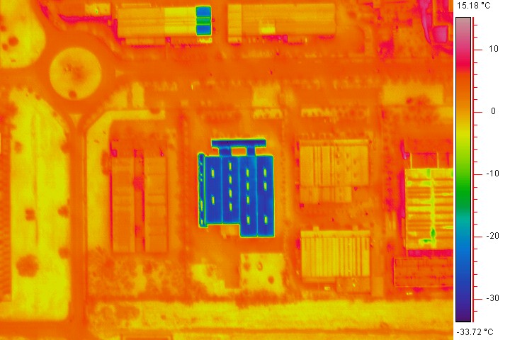
Selected urban areas will be flown over to collect thermal images using thermal cameras mounted on a specially modified survey aircraft. These images will show heat energy loss from buildings, ground features and even objects below the ground. Heat loss is recorded using the latest thermal imaging technology to create an image that quantifies thermal quality. A multi-criteria spatial decision support system will be developed to visualize and compare the cost-effectiveness and potential of different renewable energy solutions in the project cities. A series of pilot actions in the seven cities will deliver pilot training for carbon mapping, implement awareness raising campaigns and fuel poverty reduction plans.
Survey status
On February 2011, after numerous test flights in Trieste, Italy, the National Institute of Oceanography and applied Geophysics started the acquisition of the thermal images for EnergyCity.
The first city to be flown over was Bologna (Italy), however all the instruments worked perfectly; part of the selected area had to be skipped due to high traffic of Bologna's airport, which would interfere with the survey. The Municipality of Bologna changed the position of the selected zone and the flight will be completed with this month.
The city of Treviso (Italy) was flown over on the 19th of February 2011. In this case, images from the entire area were acquired without any setbacks. The altitude of the flight was about 800 meters (2 600 feet) in order to obtain the necessary ground pixel size. The acquisitions lasted a couple of hours.
In March 2011 thermal images were collected from the city of Velenje (Slovenia), Bologna (Italy) and Munich (Germany). The remaining cities will be overflown in the winter of 2011/2012
After the data collection and analysis, an interactive tool will be complied where our results can be reviewed via a Google Maps-style interface.